Backlog

No posts for a month? Yikes!

No, I’m not dead, and no I haven’t given up hiking. In fact, I’ve got a backlog of about four trips that I’ve been meaning to write up and post. I’ve just been too busy with work (and too tired after work) the past couple weeks to get it all done.

So look for those soon. I’ll be post-dating them so they’ll still appear on the calendar on the days I actually went hiking. Once I’ve got them all up, I’ll delete this post.

Posted in Uncategorized | Tagged , | Leave a comment

#17 – Solo backpacking at Wildcat Hollow

BackpackingThe trail at Wildcat HollowI had hoped to get a few of my outdoorsy friends together for the long Memorial Day weekend and organize a backpacking trip somewhere, but things didn’t work out. By the time Friday came around, I came to a snap decision: even if no one was able to go with me, that wasn’t really a reason not to go out by myself.

Of course, solo backpacking has its risks but they’re manageable with a little preparation and caution. I chose to go to a place I had been before, so I was familiar with the territory, and I wouldn’t be going very far from the main trail. Since it was Memorial Day weekend, I knew the trail would be busy, so if I got hurt someone would be along in due time.Entrance to my campsiteHere’s what I wrote in my trail journal while sitting at my small campfire:

My pack is a little heavier than I’d like it for backpacking. I’ll have to see if I can shed some pounds and shave some ounces next time. Of course, I’m soloing; if I had a companion or two, the load could be shared (tent, food, water, cook gear, etc.)

My pack weighed in at 44.8lbs. when I put it in the car. A portion of that was water and food I didn’t end up needing, but even taking that into account, I would like to drop about 10lbs. for next time.My camping kitchen

Done with dinner, and I see that I brought way too much food. I should have checked the servings on these recipes. The amount of food I have could last 4 nights easy, instead of just one.

The first course was salmon tomato couscous, and I couldn’t even eat half of what I made, despite how delicious it is. I saved the leftovers in my tupperware “mess kit”; maybe I’ll snack on it some at breakfast before I bring the rest home.

Naturally, I didn’t make the second course IĀ  had planned on, pink caterpillar roll sushi. I’ll save the ingredients for next outing.My campsiteThere’s nothing nicer than drinking some suds deep in the backwoods, miles from home or town or anywhere. Technically, I think that Wildcat Hollow is part of Wayne N.F., and so public consumption is frowned upon, but my little campsite is pretty secluded; hardly “public”.

I brought two bottles in with me, wrapped in a bundle in my hoodie along with all my cold water. Still cold enough to bead up with condensation even now. If pressed, I would probably admit that they’re unnecessary weight (especially the glass bottles), but when I’m sipping on one, I’d hardly call it unnecessary.

The Eels RunI must have found the last good camping spot in the valley. My ideal spot was already taken when I hiked in, so I kept on trucking to see if I could find something acceptable before the ridge. When the trail started to climb and none had appeared, I turned around to backtrack to spots I knew were open, though they were not my first choice. All were either too close to the trail (or directly on the trail), too close to the trailhead parking lot, or in among all the giant blowdowns from last year’s big storm.

Luckily before I had to settle for any of those, I spied this little gem of a clearing. It wasn’t an established site like most here in Wildcat Hollow, but it was open enough that it may have been used as such in the past.

That’s what I like about Wayne N.F. and other national parks and forests that have a policy of “camp pretty much anywhere”. There aren’t official campsites, but there are clearings where previous campers have left the stone fire rings in their places. Really though, anywhere that you feel like plopping down your tent, you’re welcome to.

The spot I’ve plopped in is pretty good. It’s just the right size for a solo (or any group that can fit in one small tent). It’s also just the right distance from the trail, and close enough to the creek for me to fetch stones for my fire ring and water to do the dishes after dinner.

And, my tent is right next to a spicebush, so every time I go to get in or out, my nose ends up right in the leaves and I get a good whiff of that delicious fragrance.

TrailblazeYes, this must be the last good spot for a while. Since I settled in here, three groups have gone past, and of those two came back the other way, presumably in search of a place to camp.

First, not long after I got here, a duo passed by. They came back after a short while. Then while I was cooking dinner a group of four went up the trail and came back as I was eating. Finally, a large group of seven or so marched past just after I had finished the dishes and was putting things away.

That last group must have known there were no sites open behind them, back up the trail, because they didn’t return. I imagine they found something suitable some distance up the trail, maybe as far as on top of the ridge, where I know there are two or three sites, although they were farther than I had wanted to go. Occasionally, I can hear the echoes of voices from up the valley, so they can’t be too far.

Another campsite along the Wildcat Hollow trailThe mosquitoes were eating me alive earlier, despite my smoky campfire. I should have brought repellent, even though I hate the stuff. At least they’re slackening off now as dusk grows heavier.My little campfireThe sky above is turning a shade of pink-gray that I know means there’s a beautiful sunset, even though I can’t see it here among the trees and hills. The forest is taking on a haze of dark green shadow. I’ve piled the last of my collected wood on the fire to keep the night at bay a little while longer, but it will soon fade to orange embers and the darkness will creep in.

The canopy is too thick for much starlight to filter down, and the moon isn’t full enough for more than a few feeble beams to penetrate. In the darkness, I have the gurgle of the nearby stream to lull me to sleep.

A huge tear in the valley canopy from last year's stormSNAP!Huge blowdown from last year's stormHuge tree throw, uprooted by the wind in last year's stormCampsite among the blowdownsCampsite too close to the trail for my tastes

Solo backpacking at Wildcat Hollow

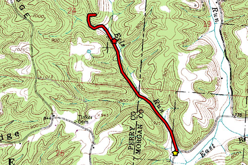
Solo backpacking at Wildcat Hollow, 2.4 miles. Yellow star is the parking lot and trailhead, red star is about where my campsite was.

Posted in Backpacking, Hiking Trips | Tagged | Leave a comment

#16 – Dow Lake Kayaking

Kayaking / BoatingPicnic spot on the lake shoreI’ve been up to Burr Oak Lake with my kayak several times, but I hadn’t yet been out to Strouds with it yet. I guess I justified it by saying that Strouds is often crowded, but in the middle of the week it wouldn’t be as bad. Dow Lake also somewhat small, although it’s still big enough to get a decent paddle in. After work it was a bit late, but I still had some time before sundown.

Great Blue HeronSo I put in at the boat ramp and paddled around for a bit, exploring the shore around the lake. It was a hot day, but in the shade of the tree-covered hillsides it was nice and cool. I poked my nose into several little coves and folds, and investigated the edges of Big Cove. At the tip of Big cove is a marsh where I looked into some of the open water until it got too shallow or closed-in to maneuver.

Castor canadensis, the north american beaverI managed to see a lot of wildlife, though. Unfortunately, all the critters were pretty camera-shy and kept flying or swimming away if I tried to get close enough for a good picture. I did manage to snap a few of a Great Blue Heron, a Marsh Wren, and castor canadensis the North American Beaver. In fact, I saw at least two beavers if not three; I couldn’t be sure because they kept tail-slapping and going under, and then coming up elsewhere.

Marsh wrenEven on a Wednesday evening, the lake wasn’t unoccupied. I saw a number of other boaters, including a few kayakers and some people out canoeing. There was also a pontoon boat or party barge full of guys goofing off, who later sang to (yes, sang) to some girls on the shore. I found that a little curious, but at least they had good harmony. There were also a few people at the beach, but not many.

Mushroom and ceramic figureI did see something odd, though. Someone placed a ceramic figure on an open section of the lake shore where it would be in full view of people out on the lake, but concealed behind a tree from the trails. The figure appeared to be an angel, like the sort of thing you might find in old people’s yards.

It was a pretty good day to be out kayaking, though.

Picnic table on/in the lakeshoreYellow irisCattailsPicnic spotBeaver hutBeach at sunset

Dow Lake kayaking

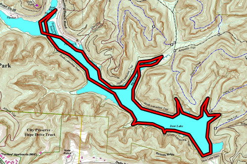
Dow Lake kayaking, approx. 5.6 miles

Posted in Kayaking | Tagged , , | Leave a comment

#15 – All the way around Dow Lake

HikingA pine plantation at Strouds RunWell, it’s been a little while since I hiked out at Strouds Run, so Jack and I headed out there today, although upon arrival I briefly questioned my decision. If you’ve ever heard me complain about Strouds Run suffering from overuse, all of that goes double for today. Since the weather was fantastic and it was a weekend, the beach was packed. Literally every parking spot in the main parking lot was taken up.

Dow Lake as seen from the northeast on Lakeview TrailFortunately, I was only driving through the parking lot for a brief look out of curiosity. Instead I found a parking spot closer to the trailhead I wanted to use. Jack and I set off on the Sundown Trail. I prefer it to the Lakeview Trail because the latter is often crowded with hikers and churned into mudholes by dozens or hundreds of boots every day.

I have occasionally seen hikers on the Lakeview Trail that aren’t what you would call prepared for a hike. That’s not to say it takes a lot to One of many mudholes on the trailprepare for a short day hike, but one would assume a hiker should have proper footwear at least. I have seen people on the trail wearing flip-flops, and once, a girl who must have tired of her flip-flops and taken them off, instead walking barefoot through the mud. Most of these ersatz hikers are probably college students who have come out to Strouds for a swim at the beach and decided more or less spontaneously to go for a hike, or else they want to swim somewhere else on the lakeshore, such as at the rope swing.

Anyhow, the crowds are another thing I wanted to avoid by taking the Sundown Trail. Jack and I Lakeview Trail blaze at Strouds Runfollowed the trail all the way to Whitsel Junction where it is coincidental with the Lakeview Trail for a short distance on either side of the junction. I kept following the Sundown Trail after the junction, but it doesn’t seem to reconnect with the Lakeview Trail at any point, so Jack and I turned off onto the Hermit Hut Trail which we followed for a while until a connector cut off to the Lakeview Trail.

Small waterfall trickling over a shallow cave on the trailWe kept on the Lakeview Trail all the way to the dam. The southern end of Dow Lake was as crowded, relatively, with fishermen as the beach was with swimmers. Every clear spot on the shoreline had at least one and often two or three, all casting lines and hoping for a bite. All told it was a busy day at Strouds.

Across the dam, Jack and I continued along the South Lakeview Trail, which I have since learned is being renamed the Hickory Trail. I discovered this fact when we got all the way to the end near County Road 20 and saw temporary paper Dow Lake beach and swimming areasigns taped over the existing trailhead signs.

From the parking area on County Road 20, we did some bushwacking through what was once a maintained trail that parallels the road, but has since become overgrown. This brought us to the picnic area, and we tried further bushwhacking to avoid having to walk along the road since traffic was busy, but a number of obstinate thorn bushes changed my mind and Jack and I instead walked along the road, watching carefully for oncoming cars.

ChrysogonumWild strawberryMayapple with fruitBear cornPossibly some kind of amanita?Ox-eyed daisy

All the way around Dow Lake
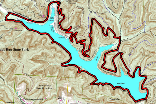
All the way around Dow Lake, approx. 9.8 miles

Posted in Day Hikes, Hiking Trips | Tagged , , , , , | Leave a comment

#14 – Sells Park to Finger Rock on the Athens Trail

HikingTrail at Sells ParkToday’s weather was perfect: 72 degrees, dry, partly cloudy. I couldn’t pass up that chance, so I took Jack out to Sells Park. I really wanted to put on some miles, so I planned to make it all the way to Finger Rock over in Strouds Run via the Athens Trail.

But first a couple stops at the usual sights. First, Lookout Point. Of course, at this point in the season the foliage is very thick and Rocks at Lookout PointLookout Point doesn’t have much of a lookout. Still, that hill is steep, so it makes a good warm up. Jack and I hiked up there to get our hearts pounding and then took a 5 to catch our breath again.

After that, we went Sells Park waterfallback down the hill and took the unofficial side-trail over to the waterfall in Sells Park. It’s been a little dry the past couple days, so the usual trickle of water has slowed to barely a drip. While we were there, I noticed that someone had spent a lot of time digging a hole in the side of a tree to install a light switch. That reminded me that not far away I had previously seen a power outlet similarly planted in the side of a tree. I assume the same person did both, but it’s still a mystery to me exactly why. Is it their idea of a joke? Maybe it’s intended as art?

Jack on the trailLightswitch in a treePower outlet in a tree

Trailblazes for the Athens TrailAfter our stop at the waterfall, we hit the Athens Trail to head east into Strouds Run. The Finger Rock Trail that I have previously written about (it comes up from the Lakeview Trail) connects to the Athens Trail. Jack and I took a brief rest at the trail junction before continuing on to Finger Rock. The trail down below is open and well worn, but on top of the ridge where Jack and I were, it’s not as heavily trod and in places the underbrush intrudes and makes the trail feel narrow and claustrophobic. It’s supposed to be a mountain bike trail, but I wouldn’t want to ride at Finger Rock Trailany speed through there without something to keep branches out of my face.

On top of Finger Rock, I spotted something odd. At first I thought it was litter, but upon closer inspection it was a red thermos jug someone has set up as a geocache. I suspect that someone else had previously found the cache and maybe tampered with it, but they didn’t rehide it properly. I left a note, but because I didn’t go out with the intention of doing any geocaching, I didn’t have anything to Finger Rock Trail gets pretty tightleave in the cache, so I didn’t take anything. I did my The Rockhouse cliffsbest to rehide the cache in what I assume was its proper place, out of sight from the trail.

After that, we returned along the Finger Rock Trail to the Athens Trail, and followed that back a ways until we cut across the White Oak Connector to the end of the Rockhouse Trail. I had never been that far along the Rockhouse Trail and never seen the Blue Ash Rockhouse itself, so I stopped to check it out. The rockhouse is another waterfall, except much larger than the one located in Sells Park. It’s hard to convey even in pictures how impressive the rockhouse is, but I tried playing with my camera’s timer and managed to snap a picture of myself, from under the overhang looking out.

Me at the Blue Ash Rockhouse

Me at the Blue Ash Rockhouse

After that, Jack and I just kept to the Rockhouse Trail and returned to the parking lot at Boulder Cove at Strouds RunSells Run. We happened upon a few hikers and their dogs going in the opposite directions and wished them a nice day, but the clouds were starting to gather and it looked like it could start raining at any moment, so I wanted to get home just in case. I had my rain jacket with me, but Jack might be unhappy to be rained on.

Unidentified wildflowerPossibly wild cherrySmall field of jewelweedHow jewelweed gets its nameRockhouse Trail blazeTrailhead sign for the Athens Trail at Sells Park

Sells Park to Finger Rock on the Athens Trail

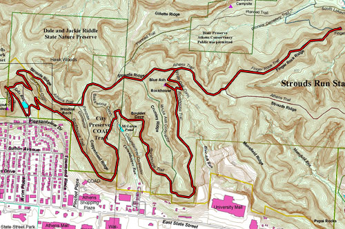
Sells Park to Finger Rock on the Athens Trail, approx. 6.2 mi

How jewelweed gets its name
Posted in Day Hikes, Hiking Trips | Tagged , , , , , , , | Leave a comment

#13 – Hope Furnace Trail at Lake Hope State Park

HikingI had a day off, so I headed out to Lake Hope State Park about 40 minutes west of Athens in Vinton County. I enjoy the parks closer to home plenty, but I’ve had plenty of hikes at Strouds Run and Burr Oak so I wanted something a little different since I had plenty of free time today. Lake Hope is located in the heart of Zaleski State Forest, so there’s plenty of hiking available.

Trail by the lakesideLake Hope is shaped something like a squiggly letter G with extra branches, or maybe a lop-sided letter H with a lump on one foot. The Hope Furnace trail goes all the way around the outside of the lake, stretching roughly 3 miles. I parked at the shelterhouse north of the beach and boat rental house. Initially I started on the wrong trail, because the map showed the trail starting right on the turnaround at the end of the road, but after realizing it wasn’t going in the direction I wanted, I came back and noticed a trailhead sign down the hill closer to the lake, out of sight from where I had been.Small streams swollen with rainwater from the day before

The weatherman was claiming 40% chance of rain, so I was counting on the weather to scare other people off the trail and I would have some solitude, even if I had to wear my rain jacket. Instead, it ended up sunny but fortunately it was still a weekday so I only saw a handful of other people; one guy in a boat and a couple on the shore, all of whom were fishing quietly. But without rain, it was extremely humid early on and although it wasn’t hot I was still Hope Furnace Trailsweating like crazy. Later on, the air dried out and the wind picked up, making it much more pleasant to hike. The only hint of the rain that was supposed to come was a distant rumble of thunder.

The trail was great. I didn’t see any blazes, but it was worn enough to be followed without any trouble at all. Worn enough that I could probably follow it after dark without a flashlight, if there was a strong moon; maybe I’ll try a night hike sometime. There’s also ample signage at the trailheads (once you look for them) and all the junctions, making it easy to find where you are even on the vague and inaccurate pamphlet maps you get from state parks.

Trail bridgeMy one complaint is that the trail is almost too improved. There have to be at least a dozen little bridges built along the trail. Sure, the bridges make the trail more accessible to everyone, even people who don’t have waterproof boots, but I feel they detract from the reason I’m out there, which is to experience nature. I can’t argue that bridges are sometimes necessary on a trail, because sometimes trails cross deep or fast creeks or small but steep ravine, but we don’t need a bridge over every little dip in the trail or trickle of water. Not Possible beaver hutonly that, but they could at least do like some state and national parks and build their bridges out of split logs rather than sawn lumber so that it looks less out of place.

Complaints aside, it was still a great day to be in the woods. I only had to contend with cobwebs across the trail and the occasional fly or buzzing insect. The trees were filled with birds singing and other little critters, including chipmunks and I believe I saw a salamander. I think I saw some beaver huts on the shore on the other side of the lake in a couple of places. At one point I walked past Large rock overhanging the swampa log laying out into the lake, and out of the corner of my eye saw and heard something slide off into the water. Later, on the way back past the same spot, I saw two turtles on the same log who also dashed into the water when they saw me coming. Consulting the internet, I believe they were midland smooth softshell turtles.

A few branches of the lake start to get very shallow before turning into grassy swamps. On the edge of one of these is a rock overhang that "S.H.S. 1886" inscription on the rockfacedrips water from the soil on top of it down into the swamp. At first I thought it was just a neat formation, as you can see on the right, but upon closer inspection I noticed something carved into the flat face of the rock. I have no idea if the 1886 date is real or not, but it’s very possible; the nearby iron furnace was built sometime soon after 1854. Now I wonder who “S.H.S.” was, but there’s either nothing on the internet about this petroglyphic graffiti or else Waterfall over a deep overhangit’s just not enough to go on for a google search.

And there are other sights to see along the trail. There are several good sites to take a break from hiking or beach your canoe and have a picnic. There are also two small waterfalls along the trail. One is just a trickle down some rocks, but the other is a decent-sized stream falling over a deep overhang. It’s probable that these two waterfalls aren’t normally so impressive, but the recent rains have put plenty of water in the ground. Maybe in the height of summer when it’s hot and dry they’ll dry up, but for now they’re nice to look at. I’ll have to remember to come back in the winter to see if they form big ice falls.

Fire pink in front of the waterfall

Unidentified wildflower

Unidentified wildflower

I saw still more wildflowers, including some at the second waterfall. There were some fire pink (silene virginica) growing in a little crevice of the rockface in front of the waterfall. I also saw wild strawberries, blue phlox, more fire pink, a plant I think is ladythumb, two flowers I can’t identify, and a single trillium giving it one last gasp before giving up the ghost. I was a little amazed to see the trillium, since they usually are very sensitive to their growing conditions and what time of year they’ll bloom, and this is definitely very late for trilliums.

Fire pink
Fire pink
Blue phlox
Blue phlox
Ladythumb
Ladythumb
Trillium
Trillium
Wild strawberry
Wild strawberry

Hope Furnace

Unidentified wildflower

Unidentified wildflower

.
.
.
.
.
.

At the end of the trail is Hope Furnace, a pig iron furnace from the mid-1800s, one of many in the Hanging Rock region that produced large quantities of iron for railroads among other things. Supposedly, some of this iron was used as armor plating on the ironclad USS Monitor in the Civil War. These days, the flat-top sandstone pyramid looks like some kind of ruins that wouldn’t be out of place on the television show Lost.

Don’t forget to check out my Flickr for even more pictures of this hike.
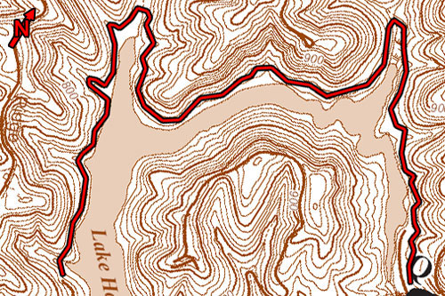
Hope Furnace Trail at Lake Hope State Park
Hope Furnace Trail at Lake Hope State Park, approx. 5.9 miles
after dark
Posted in Day Hikes, Hiking Trips | Tagged , , , , , | Leave a comment

#12 – Campground to Fire Tower, Scioto Trail State Park

HikingA few years ago my parents bought a new camper trailer for themselves, and now they spend every other weekend of their summers at various campgrounds and state parks around Ohio and elsewhere. My dad isn’t yet retired, but I like to think that they’re practicing for when he will be. Their favorite spot is at Scioto Trail State Park about a half-hour south of where they live in Chillicothe.

Morgan on the trailThis weekend was the first time they’ve taken the camper out this season, and I wanted to go visit them and have dinner. While I was there, I figured I could take at least one of the family dogs, Morgan the chocolate lab, out for a hike.

DeBord VistaHe and I headed west along the ridge trail from where my parents were camped at the campground. We took the DeBord Vista loop, but at this time of year all the thick spring foliage blocks most of the view.

View from the firetowerSpeaking of views though, the sky was only slightly overcast so I tied up Morgan at the shelter house near the fire watchtower and climbed up to the top. Morgan didn’t like being left alone, so I only had a minute or so to snap a few pictures. Well that, and I admit that although the tower was sturdy and the stairs were solid, heights aren’t exactly my favorite thing so I didn’t want to linger too long. Still, it was very impressive being able to see nothing but trees all the way to the horizon.

Consulting the map, there was supposedly another trail that more closely parallels the road while heading back east toward the campground, with a connector running to the trail I had come over on, so Morgan and I headed off to explore it. Unfortunately, the trailhead was concealed behind a building, out of sight from the road, and was overgrown as well. Once we finally managed to findfind the trail, it became clear that it wasn’t often used and the path was grown shin-deep with greenery including poison ivy.

After a while it came out into a clearing and again became difficult to follow. I think we found the trail on the other side of the clearing, as whatever trail we got on appeared to have been maintained at some point in the past, but then it crossed several downed trees and after the last one just seemed to… disappear. Not fade into the undergrowth like abandoned trails sometimes do, but abruptly.

Scioto Trail primitive camping areaFortunately, despite the unhelpful map, I knew the terrain well enough at least to be able to follow a dry creek bed. I reasoned that even if it wasn’t going precisely where I thought it was, it certainly couldn’t go anywhere but one of the two lakes in the park. But I was right and it was going where I thought it was, and it brought me out at the primitive (no electric) camping area. I have fond memories of camping there a number of times back in my Boy Scout days. From there I was able to find the trail I was familiar with again and follow the connector back to the trail I had come across on earlier.

Wild violets

Wild violets

Wild bluets

Wild bluets

Along the way, both to and from the firetower, I saw some lovely wildflowers along the trail. It looks like the trilliums are done blooming (or else simply don’t bloom in this area), but I saw more violets, little bluets, mayapples, and the exotically pitcher-shaped yellow lady’s slipper.

Mayapple

Mayapple

Yellow lady's slipper

Yellow lady's slipper

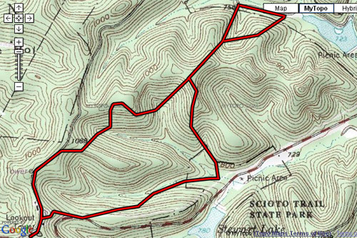
I still haven’t been able to find a high-resolution topographic map of the park, and I question the veracity of the park map offered in the pamphlet, so I have only an educated guess as to my track. The map below is the best topo I could find, from MyTopo. I overlaid the pamphlet map and traced the claimed route of the trail, but as you can see it claims I went up and down some pretty steep slopes about 5 times, when I know I only went up and down twice. Still, making this map was hard work and I’m feeling lazy, so I’ll stick with it for now.

If you try to replicate my route, be aware that there are no detailed, accurate maps available of the trails in the area, and those trails are poorly blazed with little to no signage at the trailheads.

Edit: Just a reminder, but all of the photographs here are hosted on Flickr. A widget on the right column of this page will always show thumbnails of my latest uploads, and you can always check out my Flickr photostream for all my pictures.

Campground to Firetower, Scioto Trail State Park

Campground to Firetower, Scioto Trail State Park, approx. 3.6 miles

Posted in Day Hikes, Hiking Trips | Tagged , , , , , | 2 Comments

#11 – Burr Oak, Lakeview Trail near Tom Jenkins Dam

HikingAfter work, my roommate Nick and I went to a fish fry at the Jacksonville VFW, and since we were so close we went a little further north to take a quick hike at Burr Oak before coming home.

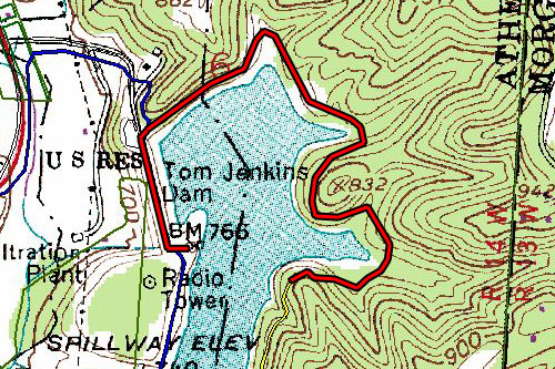
It was late in the evening, and so we couldn’t cover much distance before the sun set, but we managed to cover a little over two miles. Unfortunately, when hiking on the east shore of the lake when the sun is almost set, you’ve got the glare off the lake fully in your face.

Osprey nesting platform

Osprey nesting platform

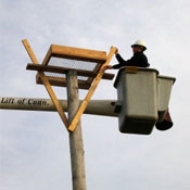
We also took a walk across the dam to the flood control house. Nearby is a rather strange construction on top of a telephone pole, like the one pictured here. It’s a square horizontal frame held up by a Y-shaped bracing coming up from the pole, and a piece of screen stretched across the bottom of the frame. There’s at least one other elsewhere in the park that I have noticed. I have since learned that this is a nesting platform built to attract ospreys to the park. Whether it’s due to the nesting platforms or not, I happen to know that the effort has been successful, since I’ve seen ospreys fishing in the lake.

Burr Oak, Lakeview Trail near Tom Jenkins Dam

Burr Oak, Lakeview Trail near Tom Jenkins Dam, approx. 2.2 miles

Posted in Day Hikes, Hiking Trips | Tagged , , | Leave a comment

#10 – Burr Oak Lake Kayaking

Kayaking / BoatingOn Monday it was raining so I had no work that day (I work construction and unless there are any indoor jobs, you can’t get anything done in the rain), and despite my earlier promise to myself I let the rain keep me indoors. Then on Tuesday I had a short day of work and when I first got home I had intentions of taking my kayak out for a few hours but ended up being lazy and taking care of some things at home. But on Wednesday at the insistence of a good friend, I finally ended my lazy streak and took my kayak up to Burr Oak.

I had a long day at work but managed to get home about 5pm and after loading up the kayak I think I managed to hit the water at about 6pm. Fortunately the sun doesn’t set until about 8:15 so I had plenty of time to paddle. I put in at Dock Area #1 and since I’ve seen most of the rest of the lake, I decided to head up the west leg towards the dam.

Even though I knew I had plenty of time, I wanted to get as far as I wanted to go and then take my time getting back, so I made a bee-line from point to point. Once I got to the dam, I meandered back and forth peeking into the coves here and there to see what I could see. Along with some nice scenery along the shoreline, I saw some more wildlife. More tree swallows eating bugs over the water’s surface, and of course canadian geese. This time I also saw a tricolored heron standing tall on the shore, and several ospreys catching fish.

I occasionally like to investigate the baited hooks that fishermen leave tied to tree branches (I don’t tamper with them, mind you, as that would be impolite; I just like to see if they’ve caught anything or if the bait fish is still alive or gone).Ā  At one hook, I found the bait fish dead and two turtles in the water having a snack. I also saw a third turtle later watching me with his head just out of the water when I came back to the dock to take my kayak out. Besides the turtles, there were a few fish I spooked in the shallows, usually only seeing the mud trail left as they scattered.

I think I finally got my GPS working. It seems that one or more of the batteries are loose in their compartment and that might be the cause of it shutting off randomly. As long as I don’t jostle it too roughly it stays on the entire time, although maybe wedging something in the battery compartment to keep them in place tightly might do the trick. This time I have an exact distance, but until I get a cable to hook the GPS up to my computer I can’t download the precise path I took.

Burr Oak Lake

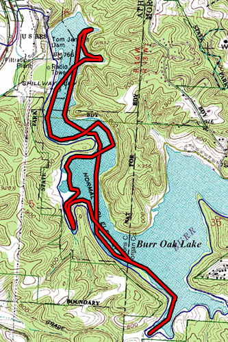
Burr Oak Lake kayaking, 5.43 miles

Posted in Kayaking | Tagged , , | Leave a comment

#09 ā€“ Wildflowers at Strouds Run

HikingAnother tiring day at work, but again I wanted to get out on the trail even for just a little bit. I wanted to take it easy so I could enjoy the wildflowers some more. In addition to the wild blue flox and redbud I had seen before, I also spotted white trilliums and some kind of bicolored flower I haven’t yet been able to identify. It’s a small flower with four petals, the two upper ones are white and the two lower ones are blue, and there are clusters of several flowers on each stem. I tried checking a few wildflower identification websites, but couldn’t find this particular flower.

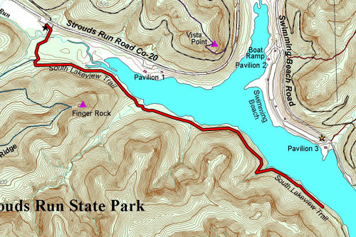
I brought Jack along with me and we spent about an hour hiking part of the South Lakeview Trail. This time instead of going all the way to the dam, instead we found a good turnaround point just about directly south of pavilion 3 on the other side of the lake.

Strouds Run, South Lakeview Trail

Strouds Run, South Lakeview Trail, approx. 2.3 miles round trip

Edit: A friend was asking about more information on my mystery wildflower to hopefully help identify it, so here are a couple pictures. They were growing in big, thick bunches in a shady area of the woods just above a slightly marshy area (on the map, not far from the parking lot around where the Pioneer Cemetery trail splits off). Hopefully we can figure this out so I can finally sleep easy at night, knowing what flower this is!

Mystery wildflower

Mystery wildflower, cluster of flowers (click for big).

Mystery wildflower

Mystery wildflower, stem and leaves (click for big).

Mystery wildflower

Mystery wildflower, stem and leaves (click for fullsized image).

Posted in Day Hikes, Hiking Trips | Tagged , , , | 3 Comments